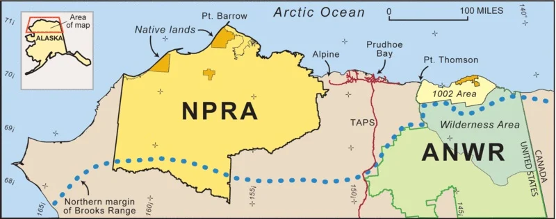
The North Slope Borough of Alaska (also known as the Arctic Slope) is a region in Northern Alaska located between the Brooks Range and the Arctic Ocean. It has an area of about 250,000km2 and administratively falls almost entirely within the North Slope Township with the exception of a small part south of Cape Hope which falls within the Northwest Arctic Township.
 |
| North Slope Borough Alaska |
Geographically, the North Slope Borough consists of the Basin north of the Brooks Range, that is, the collection area for the waters that flow from there into the Arctic Ocean, starting from the eastern end in the Beaufort Sea, near the Demarcation Bay (border with Canada), to the extreme southwest in the Chukchi Sea at the Kivalina Lagoon, just north of Cape Espenberg. More than 90% of the territory of the North Slope Borough is owned by the federal state or the state of Alaska. Specifically in the area are the National Petroleum Reserve in Alaska (NPRA), part of the Arctic National Wildlife Refuge (Anwr) and part of the gates of the Arctic National Park and reserve.
The territory is almost completely uninhabited, it is traversed by two major infrastructure projects: the Dalton Highway, a highway that connects the city of Fairbanks, in Central Alaska, with the Prudhoe Bay oil fields, and the Trans - Alaska (TAPS), a pipeline that connects the aforementioned Prudhoe Bay oil fields with the Valdez terminal in the Gulf of Alaska.
 |
| North Slope Borough Alaska |
The North Slope Borough territory consists of three distinct regions: the Coastal Plain gradually rises from the Arctic Ocean in the south to the foothills of the Brooks Mountains. The ground is flat or slightly undulating and at the base there are unconsolidated deposits of marine, fluvial, glacial and aeolian origin. The plain is about 150 km south of Barrow and narrows to the east and west.
The climate is dry polar with short, cool summers and long, cold winters. In summer, fog often forms due to the proximity of the Arctic Ocean and the ice present in it. The precipitations are little and the precipitations are in its majority snowfall during the winter. Due to the low temperatures, the permafrost is continuous throughout the region, except for the soil under large rivers and lakes. The presence of permafrost prevents surface drainage and therefore the soil is saturated and rich in organic matter. Due to the abundance of lakes created by the thaw, they cover about 50% of the surface, and due to the saturation of the soil, almost the entire region is covered with wetlands.
